Approach & Access
Approach
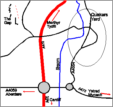
The Gap is easily identifiable as the impressive notch on the hillside to the west of the main Mythyr Tydfil (A470) road when travelling north from Cardiff (or to the south from Mythyr). At the final roundabout on the A470, when travelling north from Cardiff, take the right-hand turn signposted Ystrad Mynach (A4059). At the next roundabout (approximately 150 yards), take the first left (A4054) into Quakers Yard. Upon entering the village, and just before a pelican crossing, take the first left via a narrow bridge over the river. From here the road ascends through a built-up area until the A470 is recrossed. Just beyond this crossing is a right turn onto a narrow road passing directly beneath the quarries. Parking is readily available below both the lower and upper quarries.
WARNING: a few incidences of car vandalism have occurred in these areas so, if at all possible, park you car within visibility of the area in which you are climbing.
Layout
The climbing is located in 3 areas: The Lower Quarry, The Natural Crags and The Upper Quarry. Most of the climbing here is located in the lower quarry which is subdivided into different sectors. The Natural Crags offer only traditional climbing while The Upper Quarry offers a mix of trad and sport.

