Approach, Layout & Access
Approach
 Firstly locate Oxwich Bay, clearly signposted from most routes onto the Gower and park on the beach (£2 at the time of writing). From here there are two alternatives:
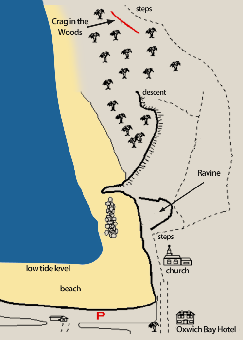
- If the tide is out, contour the right edge of the beach until the crag is visible on the right after a short spur of rock. Access is then obvious.
- Should the tide be in, follow the track past the church and after climbing a short set of steps branch off left. The track traverse the lip of a ravine and then breaks off into the forest After 400 yards trend down and leftwards, vague, until the cliff edge is gained and a small gully can be descended to the end of the cliff.
Layout
The cliff consists of two main areas: the Sea (red) Walls, obvious by name provide an easily accessible wall direct from a sea level platform: ‘The Crag in the Woods’ lies beyond this with an area of woodland surrounding it. It’s gently overhanging for most of its length with walls, grooves and arêtes in abundance.
The Far Walls
A small but reasonably long cliff reaching up to 40ft in height. There are a number of very worthwhile climbs which really pack a punch and can provide a good venue when the weather has little humidity.
Do not climb there during high humidity or after rain as the cliff is likely to be wet.
Take the path past the Church in Oxwich bay and climb the obvious steps right to the top of the hill. Now follow a path leftwards up onto the rim and along for about 400 yards until it begins to descend. Once another series of steps is reached the cliff will be seen below to the left.
Access
Much work has been done by Eugene Jones in gaining access. At the time of writing please do not climb left of the routes described, respect all projects and use only stainless steel bolts or ‘staples’.
It is imperative that these issues be followed together with not fouling the area with litter and bad language, scenarios with which climbers are so often accused.